Most people who play Flagle for the first time focus entirely on the flag tiles. They squint at the colors, try to spot a symbol, and make their next guess based on what they think they see. Then they hit six attempts and lose on a flag they probably could have solved.
The distance indicator is the part they ignored.
If you have ever wondered what those arrows and kilometer numbers actually mean in Flagle, this guide breaks it all down in plain language. By the end, you will understand exactly how to read each clue, how to combine distance with direction, and how to use the indicator to narrow down your guess from 200 countries to just a handful within two or three attempts.
This is the skill that separates average players from consistent solvers. Let's get into it.
Table of Contents
- What Is the Distance Indicator in Flagle?
- How Distance Is Calculated
- How to Read the Direction Arrow
- Combining Distance and Direction
- The Heat Indicator on Flagle Unlimited
- Common Mistakes Players Make
- Smart First Guess Strategy
- Reading the Indicator When You Are Very Close
- Quick Reference Cheat Sheet
What Is the Distance Indicator in Flagle?
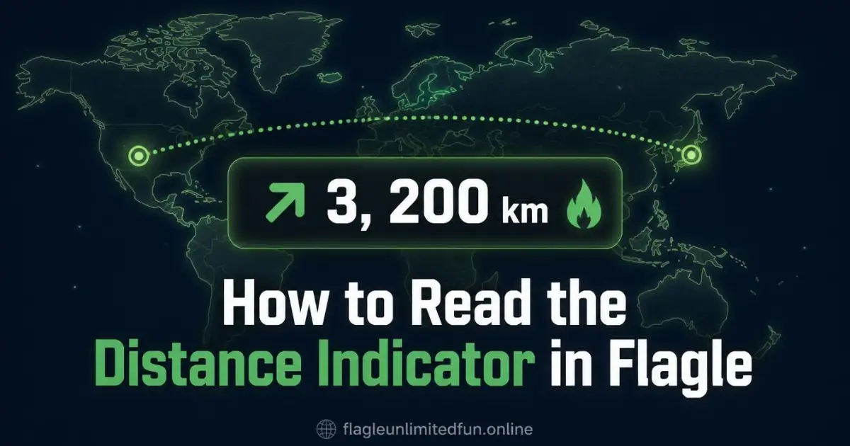
Every time you make a wrong guess in Flagle, the game gives you two pieces of geographic feedback:
- A distance in kilometers showing how far your guessed country is from the correct answer
- A directional arrow pointing toward the correct country from where you guessed
So if you guess France and the game shows 3,200 km ↘, it means the correct country is roughly 3,200 kilometers southeast of France. That one clue alone eliminates most of Europe, all of North America, and most of South America from contention.
This is geographic reasoning, and it is the core skill behind solving Flagle consistently. On Flagle Unlimited, the distance indicator works exactly the same way. Whether you are playing the Daily Challenge or a regular unlimited game, every wrong guess feeds you this information. The players who learn to read it properly solve puzzles in three attempts or fewer most of the time.
How Distance Is Calculated
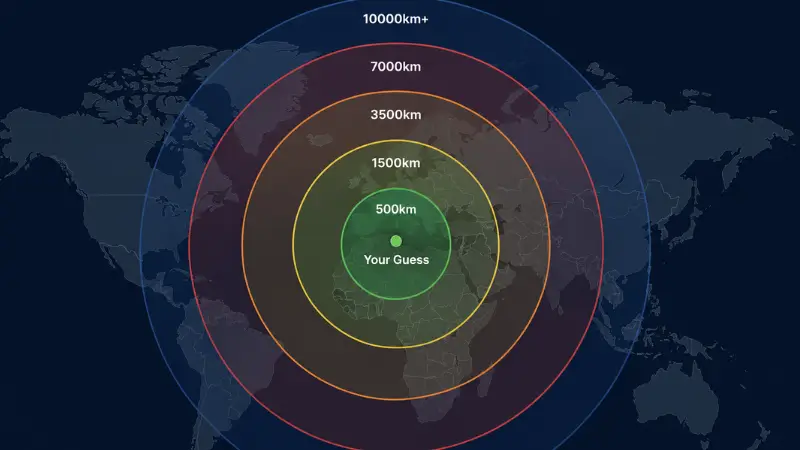
The distance shown is measured as a straight line between the geographic centers of the two countries. It is a point-to-point measurement rather than a road or travel distance, which means it is consistent and predictable. You can develop an intuitive sense for what different distances mean in practice:
- Under 500 km — You are in the immediate neighborhood. Think bordering countries or very close neighbors like Portugal and Spain, or Rwanda and Burundi.
- 500 to 1,500 km — You are in the same region. This might be France to Morocco, or India to Sri Lanka. Close but not adjacent.
- 1,500 to 3,500 km — You are on the same continent or a neighboring one. Germany to Nigeria, for example, or Brazil to Venezuela.
- 3,500 to 7,000 km — You are looking at a continental gap. The answer is likely on a different continent entirely.
- Over 7,000 km — You are far away. Think opposite sides of the world, like the UK and Australia or Japan and Argentina.
Once you internalize these rough ranges, the kilometer number stops being an abstract figure and starts being an actual geographic signal.
How to Read the Direction Arrow
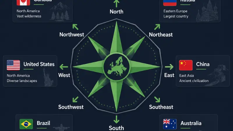
The arrow in Flagle points from your guessed country toward the correct answer. The game uses 8 compass directions:
- ↑ North
- ↗ Northeast
- → East
- ↘ Southeast
- ↓ South
- ↙ Southwest
- ← West
- ↖ Northwest
The key thing to understand is that this arrow is absolute, not relative to how your screen is oriented. North is always toward the North Pole. East is always toward Asia from Europe. This sounds obvious, but players sometimes get confused because they are thinking in terms of what looks "up" or "right" on a map rather than actual compass direction.
Here is a practical example. You guess Egypt and the indicator shows 4,800 km ↗. Northeast of Egypt at roughly 4,800 km puts you somewhere in Central or East Asia. Countries like Kazakhstan, Uzbekistan, or Kyrgyzstan become strong candidates. You can immediately stop looking at Africa, Europe, and the Americas entirely.
Combining Distance and Direction: The Real Skill
Reading distance and direction separately is useful. Reading them together is where the game really opens up.
Think of it like drawing a circle on a mental map. The distance tells you the radius. The direction tells you which side of that circle to focus on. The answer is somewhere along that arc.
Let's walk through a real example step by step.
Guess 1: Russia
Result: 6,200 km ↙ (Southwest)
What this tells you: The answer is about 6,200 km southwest of Russia. That puts you roughly in West Africa or South America. Russia is enormous, so "southwest of Russia" could be anywhere from Brazil to Senegal.
Guess 2: Brazil
Result: 8,100 km → (East)
What this tells you: The answer is far to the east of Brazil at 8,100 km. That is across the Atlantic. You are now looking at West or Central Africa.
Guess 3: Nigeria
Result: 1,200 km ↗ (Northeast)
What this tells you: You are getting close. 1,200 km northeast of Nigeria puts you in Chad, Sudan, or possibly Libya. The flag tiles should now be giving you something to work with too.
Three guesses in and you have gone from the entire world to a handful of countries in Northeast Africa. That is the power of using the distance indicator properly. For a broader look at how to structure these geographic probes, see our guide on best starting countries in Flagle.
The Heat Indicator on Flagle Unlimited
On Flagle Unlimited, the distance badge also includes a heat icon alongside the kilometers and arrow. This gives you an at-a-glance sense of how close you are:
- 🔥🔥 — Very hot, under 500 km. You are practically next door.
- 🔥 — Hot, under 2,000 km. Same region, nearby.
- 🌡️ — Warm, between 2,000 and 5,000 km. Same continent or close neighbor continent.
- 🧊 — Cold, over 5,000 km. You are far off.
The heat icon is great for quick visual feedback, but the actual kilometer number and the arrow are what let you think precisely. Use the heat icon as a gut-check and the numbers for your actual reasoning.
Common Mistakes Players Make With the Distance Indicator
Ignoring the indicator entirely
Some players treat Flagle like a pure flag quiz. They look at the revealed tiles and just guess the country whose flag they think it looks like. This works sometimes, especially if you have a strong flag knowledge base. But it fails on similar flags, partial reveals, and unusual countries. The distance indicator gives you a second, completely independent source of information. Using both together is always better than using just one. Our guide to improving your Flagle score covers this in detail.
Forgetting which country they just guessed
The arrow points from your guessed country. If you forget which country you guessed, the arrow becomes meaningless. Always keep track of what you guessed and where it is on the map mentally. The guess history on the screen helps with this.
Treating the arrow as relative to the screen
A player guesses a country in the southern part of Africa, sees an arrow pointing "up" on their screen, and thinks the answer must be in North Africa. But if the arrow is pointing North and they guessed a country that is already quite far south, North could mean Central Africa or even Southern Europe depending on the distance. Always think in terms of actual compass directions, not screen orientation.
Not using distance to eliminate entire continents
A distance over 10,000 km from your guess in Europe means the answer is basically in the Pacific, Oceania, or the far east. That eliminates hundreds of countries in a single clue. Players who do not think in these elimination terms waste guesses staying in the wrong hemisphere.
Smart First Guess Strategy
Your first guess in Flagle should not necessarily be the country you think the flag belongs to. A strategically placed first guess gives you the most useful distance and direction data possible.
Large, centrally located countries work well as opening guesses because they give you a strong geographic reference point. Russia covers so much of Eurasia that a distance from Russia immediately tells you which part of the world you are dealing with. Brazil does the same for the Americas. The Democratic Republic of Congo is useful for Africa. China anchors East Asia.
If you want specific recommendations with explanations for each continent, the best starting countries guide goes deep on exactly this strategy.
Reading the Indicator When You Are Very Close
When you get a reading under 500 km, things get interesting. At that range, the arrow becomes very precise and the list of possible countries shrinks fast.
Say you guess Poland and get back 380 km ↓ (South). That puts the answer somewhere in the Czech Republic, Slovakia, or northern Hungary. You are essentially done. One more look at the flag tiles and you should be able to commit.
The 🔥🔥 indicator on Flagle Unlimited confirms you are in the right neighborhood. At this stage, combine it with whatever you can see of the flag. If you see a cross, you are looking at a European country. If there are pan-African colors, you might have your geography slightly off and need to reconsider.
This is where flag knowledge and geographic knowledge work together most effectively. Neither one alone is as powerful as both together. If you want to build your flag recognition to complement the indicator work, start with the guide to the hardest flags to identify.
Practice Makes the Indicator Intuitive
Reading the distance indicator is a skill that gets genuinely easier with practice. After 20 or 30 games, you stop consciously calculating and start naturally sensing where on the globe a given distance and direction points. The best way to build this skill fast is to play the Daily Challenge every day and pay close attention to the indicator on every guess, even when you think you already know the answer from the flag tiles.
Quick Reference: Distance Indicator Cheat Sheet
Bookmark this for your next game:
- Under 500 km — Bordering country or very close neighbor. Check adjacent countries first.
- 500 to 1,500 km — Same region. Think same part of the same continent.
- 1,500 to 3,500 km — Same continent or neighboring continent.
- 3,500 to 7,000 km — Different continent likely. Use direction to figure out which one.
- Over 7,000 km — Opposite side of the world. Eliminate your entire hemisphere.
- Arrow points a direction — The answer is in that compass direction from your guessed country, not from the center of the screen.
- 🔥🔥 hot — Under 500 km, you are very close.
- 🧊 cold — Over 5,000 km, think different continent.
The distance indicator in Flagle is not just a hint. It is a navigational tool. Players who treat it as such solve puzzles faster, waste fewer guesses, and end up winning on harder flags that pure flag knowledge alone would not crack.
The formula is simple. Your first guess establishes a geographic anchor. The distance and direction narrow the world down to a continent and then a region. The flag tiles confirm the specific country once you are close enough. Repeat until you have the answer.
Head over to Flagle Unlimited and try it in your next game. Pay deliberate attention to the distance and direction on every single guess, even the ones you think you know. You will be surprised how quickly your scores improve.